
August 24, 2018
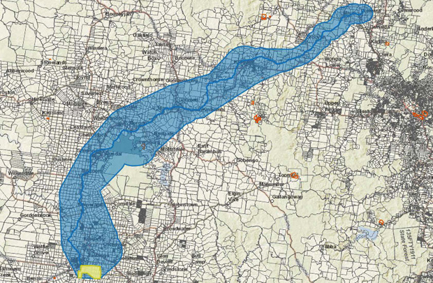
The Kingaroy Concerned Citizens Group says 174 South Burnett landholders – and 323 parcels of land – would be directly affected if Moreton Resources’ proposed coal rail line goes ahead.
The KCCG recently gained access to various documents from the State Government under Right To Information processes.
The documents include maps which show in more precise detail the rail route proposed to take coal from Kingaroy (if the mine goes ahead) to the coast.
The route mostly shadows the former Kingaroy-Theebine rail line, now being used as the recreational South Burnett Rail Trail.
KCCG spokesman John Dalton said although towns would be spared having a coal train through their main town streets, the surrounding areas would be hardest hit with the proposed route passing through many privately owned properties.
“It is the responsibility of the proponent, Moreton Resources, to engage with affected landholders in a proactive manner, and inform them of the likely impacts of coal project,” Mr Dalton said.
“This does not seem to be happening in the case of both the mine site itself or the coal rail line.”
Neil Hutton, who lives in Wessling Road at Wondai, said the proposed coal rail line would pass just a few hundred metres from his house.
He believes the noise and dust would be devastating.
“We would be unable to continue living here if the proposed coal rail line went ahead,” he said.
- Download maps extract (including Lot numbers) (8.7Mb PDF)
- External link: KCCG documents archive
Related articles:
- Moreton Delays Release Of EIS
- Protest Group Targets Rail Crossings
- Moreton Says ‘Selective Mining’ Would Extract Cleaner Coal
- Coal Mine Decision ‘By Next Christmas’
- SB Coal Project ‘Well-Advanced’
- Moreton Outlines Plan To Pay Off Tax Debt
- Moreton To Secure Cash Flow
- Taabinga Declared A Coal-Free Community
- Moreton Aims For Coal In 2019
- Moreton ‘Praises’ KCCG Art Project
- Mine Fight Comes Alive With Art
- Moreton Gives Council Coal Mine Update
- Photo Shoot Captures Coal Mine Site
- KCCG Says Moreton Statement Misleading
- Moreton Aims For Rail Corridor
- Moreton Presses On With Mine Plan
- Moreton To Push Ahead With EIS
- Moreton Tax Bill Still In Limbo
- KCCG To Ramp Up Campaign
- Elks’ Role Cut Back Again
- Moreton Appoints Project Manager
- Moreton Starts Mine Approval Process
- KCCG To Make Mine Submission
- Moreton Applies For Mining Licence
- Greens Back Kingaroy Mine Protest
- KCCG Calls For Coal Permit Buyback
- Elks To Resign As Moreton CEO
- Another Step For Moreton Resources
- KCCG Demands Pre-Mining Health Tests
- Crowd Votes Down Mine … Again
- Moreton Faces $8m Tax Bill
- KCCG To Hold Second Anti-Mine Forum
- KCCG Plans Second Forum
- Nannas Take To The Highway
- Kingaroy Coal Mine To Require Federal Approval
- Moreton Looks For Silver Lining
- Between A Rock And Taabinga Village
- Moreton Re-issues Update
- Market Awaits Moreton News
- Moreton Predicts 400-600 Jobs At Mine
- Airport Blocks Cut From Coal Permit
- KCCG Rejects Phone Poll
- Phone Poll Backs Mine: Moreton
- Moreton Takes Mining Plan Out To The People
- KCCG Will Speak To Council
- Nannas Knit Against Mine
- KCCG Meets With State Government
- Coal Mine Fight Spreads
- Moreton Resources Unveils Mine Partner
- Meetings To Discuss Mine
- Moreton Plans To Start Seeking Permits
- Moreton’s Coal ‘Too Expensive’
- Kingaroy Coal Mine? No Way!
- Public Meeting To Discuss Coal Mine
- Stanwell Still Says ‘No’
- Moreton Releases Mine Study Results
- Moreton Resources Eyes Rail Link
- Moreton Buys More Resources
- Mining CEO Talks To Council
- KCCG Sees No Future For Mine
- Green Light For ‘Next Step’
- Moreton Board To Consider ‘Next Step’
- Moreton Resources Splits Off South Burnett Holdings
- Moreton Resources Extends Licence
- Controversial UCG Plant Vanishes
- UCG Plant Starts To Disappear
- Moreton To Begin Mine Concept Study
- Moreton Responds To MP’s Comments
- Moreton Aims To Press On
- Stanwell ‘Rejecting Billions In Savings’
- Stanwell Rules Out Moreton Coal
- ‘Enough Coal For 30-Plus Years’
- Concept Study Next Step For Proposed Coal Mine
- Moreton Triples Coal Estimates
- Coal Mine Review Delayed To July


Who is going to pay for the resumption of land, the construction and maintenance of said proposed railway line? I doubt that either the State or Federal Governments would contribute given the ever-increasing massive debts they both have. Perhaps it could be Australia’s richest miner?? 🤔