
May 15, 2020
A new study has found that Wondai residents would be at the greatest risk of suffering severe symptoms if the South Burnett had an explosion of COVID-19 cases.
Residents living in the Proston, Hivesville, Murgon, Nanango and Yarraman postcode areas would be at a similar risk if a COVID-19 outbreak occurred in those postcode areas.
Those living in Mondure, Wooroolin and Cooyar would have slightly less risk, while those living in the Kingaroy or Goomeri postcode areas would have lower risk again, with Kilkivan the lowest of all.
The information comes from a new study by the UNSW Business School and actuarial consulting firm Finity.
The study has found the South Burnett as a whole has a vulnerable population which would be at severe risk if a COVID-19 outbreak happened here.
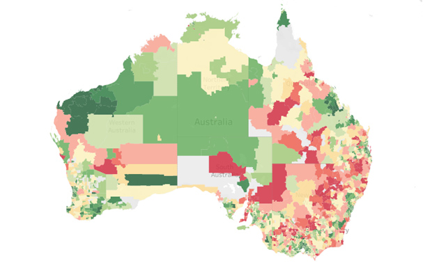
UNSW and Finity have prepared a map of Australia – the COVID-19 Susceptibility Index – which links co-morbidities (such as age, cancer, diabetes, cardiovascular disease, obesity and lung disease) against the characteristics of individuals in households (such as age and sex).
The result is a risk rating by postcode area.
The Index models risk based only on co-morbidities. It does not model infection transmissions.
The study sets Wondai’s risk rating at 100 (the highest); Hivesville and Nanango at 99; and Murgon, Proston and Yarraman at 97.
Mondure and Woorolin’s risk rating is 87 and Cooyar 86.
Kingaroy has a 76 risk rating; Goomeri 74; and Kilkivan 56.
Researchers said the results of the study will help Australian authorities make decisions about selectively lifting lockdown or social distancing measures, enabling a balanced approach to reinvigorating the economy while keeping the population safe.
Finity principal and lead researcher Aaron Cutter said the initial results of the study indicated regional areas were more susceptible to severe symptoms if COVID-19 was contracted.
“The results are preliminary but show that while the initial wave of COVID-19 cases was concentrated around capital cities due to population density and proximity to cruise ships and international airports, these areas have lower proportions of highly susceptible individuals compared to the rest of Australia,” Mr Cutter said.
“The Index reveals that regional areas actually have greater susceptibility – not only because of age but due to a number of other key characteristics.
“As Australia’s COVID journey matures, this preliminary information can assist attempts to model the pandemic’s development as well as help inform decisions regarding preventative measures.”
The Department of Health has approached the research team to use the Index.


Goodness gracious me!! Does this mean that residents orta flee Wondai pronto? Or are the residents of Wondai really decrepit and ready to fall off their perches anyway?
I expanded the map and had a squizz at a lot of places all around Australia and some of it is interesting. Couldn’t find a listing for Cherbourg though. And Woorabinda has a listing of 5 while Wondai is 100 (ie Wondai has 20 times more risk than Woorabinda). Blimey, if I lived in Wondai I would be leaving for Woorabinda ASAP, one of the safest all around except Newman and Tom Price, both with a score of 1.