
June 21, 2016
Toowoomba Regional Council will hold community meetings in Cooyar and Yarraman following the approval of the Consolidated Flood Risk Assessment and Planning Evaluation Report at Tuesday’s Council meeting.
TRC Planning and Development Committee chair Cr Chris Tait said the latest report was part of one of the most comprehensive flood studies done in Australia.
“The project’s main aim is to improve flood risk management and raise community awareness about flood risks across the region,” Cr Tait said.
“Region-wide consultation about the outcomes of the detailed flood risk assessment and proposed planning responses will be launched around the end of July. Dates and venues will be notified soon.
“Council is developing a Flood Risk Information Portal that will be available online for all residents to better understand their flood risk and how this might be addressed in the Planning Scheme.
“Before the consultation period, owners and residents of lots that are identified as being subject to flood risk will be contacted individually.
“Council staff will be visiting communities that have been identified as requiring more detailed planning and policy responses in order to better manage their existing or future flood risk.
“Residents will be able to speak one-on-one with planning staff to get more information and discuss the proposed policy responses and what this means for them.”
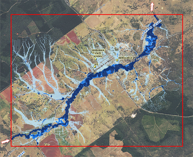
As well as Cooyar and Yarraman, meetings will also be held at Oakey, Jondaryan, Crows Nest and Maclagan/Quinalow.
Following the on-location consultation sessions, residents from all parts of the Toowoomba council area will be able to book appointments with Council officers at the Little Street Service Centre in Toowoomba to gain more information about their property and discuss proposed policy responses.
Cr Tait said community feedback would be considered, and where necessary, adjustments would be made to the Draft Planning Scheme Amendment before it was submitted to the State Government for review and statutory consultation.
“The latest report is part of Council’s commitment to flood risk management, with particular consideration for how flood studies will affect and influence land use planning and development assessment applications.
“It offers greater clarity around what type of development is best suited to different areas, depending on the flood risk. Zoning changes could be used to limit futures increases in risk.
“For example, for land that is known to be susceptible to flood risk, it would mean there would be restrictions on where, and what type of, development could occur and controls about the level and form of buildings.
“This not only protects human life and property, but also has a beneficial flow-on effect for the insurance sector.
“A greater level of detail means insurers can locate individual properties more accurately on flood risk maps and rate premiums accordingly.
“These detailed assessments of flood risk build on the 42 professional engineering reports about flooding behaviour that were completed last year at 35 locations across the region.
“These were verified with additional information and personal accounts from people, adding to our knowledge of past flood events and aiding the flood studies.
“We are collating the best information possible to better inform people about the likelihood and impact of future flooding.”


