April 30, 2015
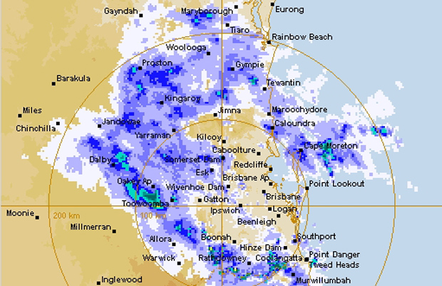
The Bureau of Meteorology this morning issued a severe weather warning for parts of southern Queensland, including the Wide Bay and Burnett, Darling Downs and Granite Belt areas.
A flood watch is current for parts of the Capricornia, Central Highlands and Coalfields, Wide Bay and Burnett, Southeast Coast, Darling Downs and Granite Belt and Maranoa and Warrego forecast districts.
Locations which may be affected include Kingaroy, Gympie, Dalby and Toowoomba.
[11:26am]
* * *
Synoptic Situation
A strong upper trough will move east into the south-eastern interior of Queensland on Friday and then will move off the southern coast during Saturday.
A surface trough will deepen near Fraser Island during Friday, with a low pressure system most likely developing and slipping southwards over southern Queensland waters during Friday evening and Saturday morning.
A moist wind flow to the south of the surface trough is expected to combine with the upper feature to generate heavy rain, which may lead to flash flooding, over areas south-east of about Hervey Bay to Dalby to Warwick on Friday; 24 hour totals of 50 to 150mm are likely over inland parts, increasing to 200 to 400mm nearer to the coast with some isolated heavier falls possible.
The heavy rain areas should contract south-east during Friday, gradually clearing the Gold Coast during Saturday morning.
Damaging winds, with peak gusts of around 90km/h are possible from tomorrow afternoon near coastal areas as the surface trough develops offshore.
The low will also most likely generate large swells as it slips southwards during Friday and early Saturday, with dangerous surf developing about Fraser Island, Sunshine Coast and Gold Coast beaches.
Locally heavy falls are also expected today though are more likely to be associated with thunderstorms. Severe thunderstorm warnings will be issued as necessary.


