February 28, 2022
A number of roads have re-opened across the South Burnett but extensive flooding continues along Barkers and Barambah creeks.
The Burnett Highway between Nanango and Goomeri re-opened earlier on Monday along with Cherbourg Road, providing access to Murgon and Cherbourg communities.
However, Angels Bridge on the Barambah-Murgon Road at Redgate has re-opened under restrictions and will require further repairs.
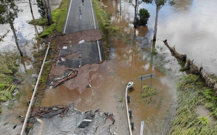
And significantly, the Bunya Highway remains closed at Krebs Bridge, just south of Murgon.
The South Burnett Local Disaster Management Group provided the list of road openings in a statement on Monday evening.
The LDMG confirmed there had been significant failures to the pavement on the approaches to Krebs Bridge.
“This bridge remains closed until later in the week, and Queensland Police Service advises that it is an offence to drive past road closure signs and will be enforced,” and LDMG spokesperson said.
“Council crews continue to make their way across the road network to undertake assessments, particularly as water levels recede and they can reach currently inaccessible areas.
“Numerous roads and floodways have substantial damage including road surfaces and culverts which may leave roads temporarily impassable.
“This is a timely reminder not to enter floodwaters as you can’t be certain of conditions beneath. To maintain community safety and avoid any preventable risks, please do not drive around areas damaged or impacted by flood.
“Council will be working hard to re-open roads as the water recedes and appreciates your patience and understanding.
“The LDMG is continuing to work with local businesses in relation to grocery and food supplies with a further updates expected to be provided tomorrow (Tuesday).”
- Related article: Council Issues Water Alert
* * *
Rainfall Totals
Rainfall totals from Thursday to Sunday varied across the region. Here are some submitted by readers:
- Blackbutt North – 380mm
- Booie – 140mm
- Booie – 150mm
- Cloyna – 200mm
- Crawford – 122mm
- East Nanango – 170mm
- Ellesmere – 145mm
- Kingaroy – 124mm
- Kingaroy – 142mm
- Kingaroy East – 140mm
- Manyung – 240mm
- Marshlands Bridge – 214mm
- Murgon – 235mm
- Nanango – 183mm
- Nanango – 250mm
- Nanango-Brooklands Road – 180mm
- Pimpimbudgee – 145mm
- Sandy Ridges – 251mm
- South Nanango – 176.5mm
- South Nanango – 256mm
- South-East Nanango – 230mm
- Stonelands Road – 207mm
- Wattle Camp – 232.5mm
- Wondai – 160mm
- Wondai – 190mm
- Wondai – 195mm
- Wondai – 207mm
- Wooroonden – 230mm
- Yarraman – 254mm
- Yarraman – about 300mm
* * *
Latest Flood Warning
Issued by BOM at 10:55am on Monday:
- Stuart and Boyne rivers: River levels are easing and no further flooding is expected in the Stuart and Boyne rivers. No observations are currently available for the Boyne River at Dunollie. However, river levels are expected to be below the minor flood level. The Boyne River at Dunollie is likely to remain below the minor flood level (2.50m) during Monday.
- Barker and Barambah creeks: River rises and areas of minor to major flooding are occurring along the Barker and Barambah creeks. Major flooding is occurring along the Barker Creek at Glenmore. Moderate flooding is occurring along the Barambah Creek at Ficks Crossing. The Barambah Creek at Stonelands is currently at 9.95 metres and rising, with minor flooding. The Barambah Creek at Stonelands is likely to reach the moderate flood level (10.00m) early Monday afternoon. The river level is expected to remain above the minor flood level (8.50m) during Monday. The Barambah Creek at Brian Pastures was at 6.85 metres and rising at 2:45pm Sunday, with minor flooding. Based on upstream river levels, the river level is expected to be above the minor flood level. The Barambah Creek at Brian Pastures is likely to fall below the minor flood level (6.00m) Monday evening.
The next warning will be issued by BOM 11:00am on Tuesday.
- External link: Flood warning for the Burnett River


