February 24, 2022
Police have renewed a warning to residents in southern Queensland to re-think their need to travel, with further persistent heavy rainfall expected.
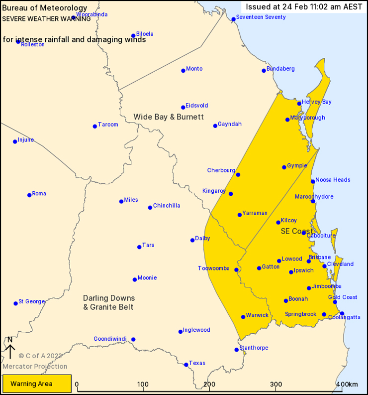
Areas that could be affected including the South West, Darling Downs, Wide Bay-Burnett, Sunshine Coast, Moreton, Gold Coast, Logan and Brisbane.
A police spokesperson said locally intense rainfall along with a damaging wind risk and embedded severe thunderstorm activity can result in extremely hazardous conditions on roadways.
Trying to navigate these hazards, either in vehicles or on foot, can be extremely dangerous as water levels can rise and fall quickly.
Members of the public have been urged to avoid flooded roads, creeks and bridges likely to be impacted by rapidly rising water.
Motorists have also been reminded that road closures and road conditions can change rapidly.
If driving, travel with extreme caution and drive to the prevailing weather and road conditions. Plan your trip, allow extra travel time, incorporate travelling at lower speeds, delays and diversions and remember: If It’s Flooded: Forget It.
Police also have reminded parents to ensure their children were not playing in flood-prone waterways, watercourses and drains as water levels can rise quickly.
* * *
Issued by BOM at 11:00am on Thursday:
An upper low will move slowly eastward across southern Queensland throughout Thursday before rotating over the south-east on Friday.
A surface trough near the south-east coast will deepen in response to this upper weather system on Thursday.
Overnight and into Thursday morning, the main trough and heavy rainfall remained just off the coast, however this trough may move or redevelop back over land later on Thursday and then remain slow-moving into Friday, producing periods of heavy rainfall with embedded thunderstorms.
Heavy rainfall which may lead to flash flooding is expected to increase later on Thursday and overnight across parts of south-east Queensland, and continue into Friday. Six-hourly rainfall totals between 80mm and 120mm are likely, reaching up to 180mm over areas east of Gympie to Jimboomba. The heaviest falls are expected through the latter parts of Thursday into Friday morning.
Locally intense rainfall leading to dangerous and life-threatening flash flooding is possible on Thursday evening into early Friday, with the mostly likely area about the coast and nearby inland north of Brisbane. In these areas, six-hourly rainfall totals up to 300mm are possible.
A separate Severe Thunderstorm Warning will be issued if very dangerous storms with intense rainfall are detected.
Damaging wind gusts with peak gusts in excess of 90km/h are possible from late Thursday afternoon over the south-east coast district, east of about Gympie to Mt Tamborine although most likely near the coast north of Brisbane.
Locations which may be affected include Warwick, Gold Coast, Toowoomba, Brisbane, Maroochydore, Gympie, Caboolture, Ipswich, Jimboomba, Kingaroy, Hervey Bay, Maryborough, Mount Tamborine and Redcliffe.