February 24, 2013
South Burnett residents should be on alert for heavy rain and possible flash flooding from midnight tonight as a large weather system hits the State’s south.
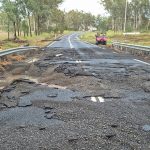
The Bureau of Meteorology issued a warning for the Wide Bay-Burnett at 4:00pm this afternoon to prepare for a surface trough currently located off the central and southeast Queensland coast to make landfall early tomorrow morning, bringing 24 hour rainfall totals of up to 200mm.
Areas of heavy rain are expected to develop overnight and tomorrow, with periods of intense rain delivering totals of up to 100 mm over a six-hour period.
Locations which may be affected by this system include the South Burnett, Gympie, Bundaberg, Gladstone, Hervey Bay, Fraser Island, the Sunshine Coast and adjacent hinterland areas.
Brisbane, Ipswich and the Gold Coast are also expected to be impacted by the storm.
Emergency Management Queensland advises that people should:
- Avoid driving, walking or riding through flood waters
- Keep clear of creeks and storm drains
- For emergency assistance contact the SES on 132 500
The next warning is due to be issued by 10:00pm.
Warnings are also available through TV and radio broadcasts, the Bureau’s website or by phoning 1300-659-219.
UPDATE 10:35pm:
The Bureau of Meteorology has revised its forecast slightly since this afternoon.
In its 10:00pm update, the Bureau now says the upper trough and low are expected to move slowly eastwards while amplifying tonight and during Monday. The surface trough off the central and southeast Queensland coast is expected to move onto the coast at some time tomorrow.
Areas of heavy rain are now expected to develop during the course of Monday, rather than from midnight tonight.
However, the outlook for the amount of rainfall that could occur and the flash flooding that could result from such falls remains the same.
UPDATE 7:00pm Monday, February 25:
The Bureau’s latest forecast issued at 4:56pm this afternoon:
“Currently, the heaviest rain is located on radar over the Sunshine Coast and hinterland, extending into the Burnett region and south to Ipswich. In the past six hours highest rainfall totals have included 81mm at Lake MacDonald Dam, 78mm at Peachester, 68mm at Mt Castle and 63mm at Toowoomba.
“The focus for heavy rain is expected to contract north into the Wide Bay and Burnett and Capricornia districts during Tuesday.”
UPDATE 10:45am Tuesday, February 26:
The Bureau’s latest forecast issued at 10:42pm this morning suggests the South Burnett is now over the worst of yesterday’s heavy rain:
“The areas of heavy rain are expected to decrease from the south over the Southeast Coast district north of Brisbane and through the Wide Bay and Burnett districts from this evening.”