
Cr Gavin Jones
October 11, 2017
The days of whingeing about how bad your road is to get the Council to pay some attention to it are rapidly drawing to a close, according to Cr Gavin Jones.
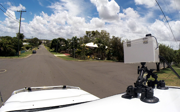
Almost a third of the region’s 3500km road network has now been mapped by the South Burnett Regional Council’s new automated road asset condition assessment system (RACAS).
The Council put the RACAS system to work in August, and so far it has mapped the condition of 1000km of roads; located every pothole, corrugation or other defect on them; and mapped their precise geographic coordinates.
Cr Jones told Wednesday’s Council meeting the new system’s thorough and impartial analysis of the real state of the region’s roads meant the entire road network could be mapped by early next year.
It also meant the days of whoever whinged the loudest about how bad their road was were drawing to a close.
“Whingers in future will be ignored,” Cr Jones told the meeting.
“RACAS identifies high priority defects and these will be attended to first.”
Cr Jones said what the mapping exercise was finding was that in many cases, otherwise good roads were being turned into annoyances by damaged patches.
The majority of a road might be fine, but damaged patches were continually annoying drivers who had to use the road. This created the perception the road’s overall condition was worse than it really was.
However, because RACAS was impartial and precise, these damaged patches could be identified and remedied.
This restored the entire road to a good average condition without the need for a total rework, allowing road crews to get through more repairs in less time.
“The squeaky wheel is being replaced by science, and I’m confident we’ll see a massive improvement to our region’s roads in the next 18 to 24 months,” Cr Jones said.
“I want to stress that I still encourage the public to ring and tell us about bad patches on their road.
“But say bad patches, don’t say the whole road is bad because in most cases it’s not.”
* * *
Council road crews are undertaking – or will soon start – the following major roadworks projects:
- Reconstruction of a section of concrete footpath in Hart Street, Blackbutt between the Radnor Hotel and Scott Haven because the old surface is deformed
- Constructing a children’s crossing and other pedestrian facilities on Kingaroy Street opposite Taabinga State School
- Reconstructing a section of Corndale Road east of the Class and Towns Road intersection due to excess deformation of the sealed surface
- Grader maintenance and gravel resheeting in the Booie, Maidenwell, Memerambi, Goodger, Ellesmere, Wengenville, Mondure and Kitoba areas
* * *
Related articles:











Am I ignorant of something here? I still don’t see how this process gets roads fixed quicker. I’d be more interested in knowing what the minimum wait time is a road that is severely damaged to be repaired with this new system, rather than knowing whether Council is aware of is condition. After all, there are countless numbers of ‘road damaged ahead’ signs placed around the region which I assume means Council is aware that the road is damaged, the problem is there’s no crew to come and fix them.
At the end of the day if there is still the same number of graders and staff, it’s highly unlikely that damaged roads will be fixed any quicker than what they are now. Which means people like me will still whinge but am guaranteed to get ignored by my local Councillors. Please explain Mr Mayor and Cr Jones, please don’t ignore me.
Hi Bill, All your questions were answered at the free SBRC public information sessions held across our region last month. Cr Jones carefully explained with demonstrations, the purpose and benefits of this mapping system and also how this will shorten lead times, save costs etc. In my experience; ‘If you don’t measure it, you can’t manage it’. I believe this is a great initiative.
What’s the lead time on the mapping? 4-5 months? 4-5 months to map the conditions of the road network!
One decent downpour and the conditions would have changed significantly and require remapping. Invest the money on graders and enable the operators to reform the roads with a crown, cross fall and drainage system.
The current strategy of running a grader blade across it once or twice to remove the corrugations is short-sighted. Clearly not enough resources allocated to road maintenance in the SBRC. Until adequate resources are directed to roads, this will be an ongoing debacle.