February 20, 2015
UPDATED 8:00am:
Tropical Cyclone Marcia has crossed the Queensland coast near Shoalwater Bay as a Category 5 cyclone.
Gales are occurring about coastal and island communities between Sarina and Double Island Point, and are expected to extend inland to Moura, Biloela, Monto, Taroom and Mundubbera today.
TC Marcia has sustained winds near the centre of 205km/h per hour with wind gusts to 285km/h.
The warning zone stretches from Sarina to Double Island Point and extends inland to Moura, Biloela, Monto, Taroom, Mundubbera and Murgon.
* * *
At 11:00am on Thursday, South Burnett Mayor Wayne Kratzmann chaired a meeting of all relevant local agencies – police, ambulance, QFES and SES – at the SBRC Council Chambers.
He said all were “ready to go” if there was an emergency in the next 24-48 hours.
The Regional Disaster Management Committee met again at 3:00pm and received another briefing from the Bureau of Meteorology.
It heard that rainfall in the South Burnett should become heavier on Friday afternoon and continue over Friday night but would be less than feared on Thursday morning.
(NB. This was before the cyclone reached Category 4 intensity)
Mayor Kratzmann urged local residents to stay off the roads unless it was an emergency as the local road network could get a “hammering”.
“The best place to be, certainly tomorrow and over the weekend if you can be, is in your home and to stay here in the South Burnett,” he said.
Officer-in-charge of Kingaroy Police Duane Frank also urged residents to stay off the roads overnight and emphasised: “If it’s flooded, forget it”.
Another update from the South Burnett Disaster Management Committee will be provided after 10:00am on Friday.
* * *
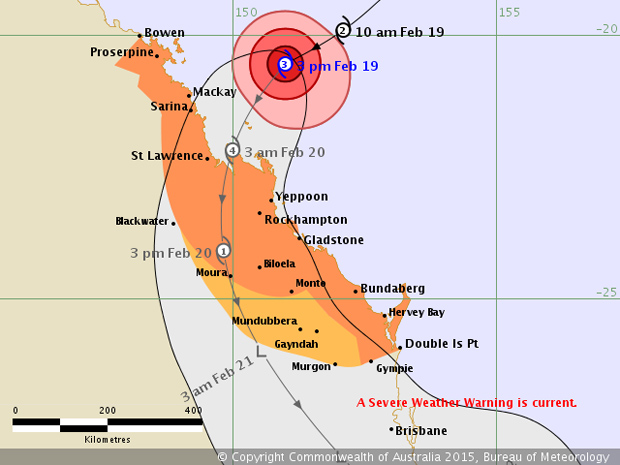
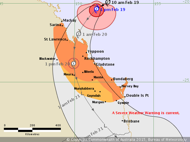
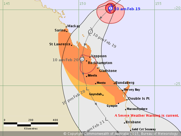
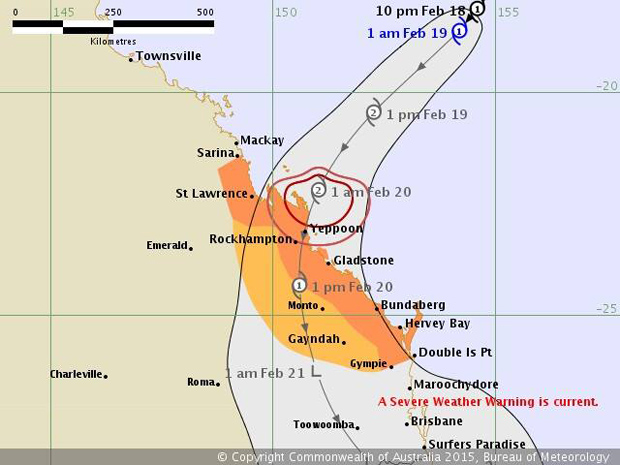
How Cyclone Marcia Grew During Thursday
Issued 4:04pm:
Issued 2:02pm:
Issued 11:03am:
Issued 1:00am:
* * *
Issued 11:32pm:
Heavy rain and locally damaging wind gusts are possible from the coast to the ranges between Double Island Point and Brisbane, extending to the State’s southern border and the eastern Darling Downs and Southern Burnett later today and Friday.
The heavy rain may lead to flash flooding, with some 24 hour totals in excess of 300mm likely. Damaging wind gusts may reach around 90 km/h, mostly near the coast and ranges.
A flood watch is current for the Wide Bay and Burnett, South-East Coast and the Darling Downs and Granite Belt District forecast districts.
Locations which may be affected include Warwick, Gold Coast, Toowoomba, the Lockyer Valley, Ipswich, Brisbane, Caboolture, the Sunshine Coast, Kingaroy and Gympie.
- Related article: Cyclone Marcia Heading For Coast
[Published earlier as “Video Update From Mayor” and “Marcia Forecast To Hit Category 5”]




The flag to the Mayor’s right is not in the correct position, check with Damien Tessmann, he is/was a member of Toastmasters. This from their protocol information. NOTE: 1. The Union Jack must always appear to the audience placed in the left top corner.
I couldn’t agree more Pete. When there is a Category 5 cyclone about to hit the coast, and lives could be at risk, correct protocol is the main priority. God Save The Queen, her heir and successors and long may Brittania Rule The Waves. Alfred the Great couldn’t stop the tide. maybe waving the Union Jack will stop Cyclone Marcia in her tracks.
Oops, sorry I meant King Canute. Alfred was the one who burnt the cakes. So much royal trivia to remember in a time of crisis. Stiff upper lip boys!
Easy fix. Remove the Union Flag from the Australian Flag!!