
October 27, 2014
South Burnett Regional Council will be asked to provide members of the Nanango Tourism and Development Association (NaTDA) with a private tour of the McCauley Weir area at South Nanango.
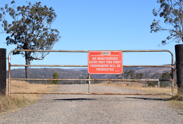
The group says it will write to the SBRC to request a tour so they can inspect the current state of McCauley Weir Road and the dam’s facilities.
At NaTDA’s October meeting last Thursday night, President Gloria Kirkness said the group remained committed to its long-term goal of seeing McCauley Weir re-opened to the public.
However, they were aware Council had concerns about public safety.
NaTDA would like to inspect the area in person so members could gain a better understanding of the issues, Mrs Kirkness said.
If Council was unable to arrange a guided inspection, NaTDA would request Council provide keys to the weir road’s locked gate so members can undertake a group inspection by themselves.
Mrs Kirkness said there may be ways the community could partner with Council to resolve the matter and reopen the popular fishing spot.
She said NaTDA supported local fishing groups who believed the weir could be developed into a family oriented recreational site and tourist attraction if it was re-opened.
The weir formerly supplied Nanango’s water access was closed by Nanango Shire Council about a decade ago.
The South Burnett Regional Council has maintained the ban on public access since amalgamation, claiming the road to the weir is unsafe.
Council has also expressed concerns that the ageing water treatment facilities may pose safety risks.
NaTDA first wrote to the Council about reopening access to the weir in May.
They were advised Council’s roadworks committee would re-examine the issue when it met in September.
Related articles:









Gee, if you were cynical you could almost think there was something fishy going on and not at the weir.
You can still walk from 7 Mile Diggings about 1km upstream, also when the creek’s dry you could drive along the sandy bank. Also Druce Road up at Archookoora Forestry has a giant 2m ditch on the way up the mountain. My dad’s truck nearly fell in the ditch and we had to walk back 2km to get help.
Also, how bad could it possibly be. If it’s that bad why don’t they take some pictures of the actual road damage. Residents use the road, so it probably isn’t that bad. Why can’t people walk down to the weir? We want answers!